![](/images/other/stat-length.png)
![Tocht Stappen La Motte-Saint-Martin - Le Conest depuis le Majeuil - Photo](https://media.geolcdn.com/t/1900/400/c6e2a8fd-f5ff-45a4-8e51-c79841c3ed21.jpg&format=pjpeg&maxdim=2)
Le Conest depuis le Majeuil
GuyVachet
Gebruiker
![Lengte](/images/other/stat-length.png)
![Max. hoogte](https://static1.geolcdn.com/siteimages/upload/files/1508320355ic_sort_altitude_max_24dp.png)
![Positief hoogteverschil](https://static1.geolcdn.com/siteimages/upload/files/1508320355ic_sort_den_pos_24dp.png)
![Km-Effort](/images/other/stat-length.png)
![Min. hoogte](https://static1.geolcdn.com/siteimages/upload/files/1508320355ic_sort_altitude_min_24dp.png)
![Negatief hoogteverschil](https://static1.geolcdn.com/siteimages/upload/files/1508320355ic_sort_den_neg_24dp.png)
![Boucle](https://static1.geolcdn.com/siteimages/upload/files/16400158638029165_repeat_loop_refresh_sync_direction_icon.png)
![Stappen](https://static1.geolcdn.com/sitytour/trail-icons/101.png)
5h15
Moeilijkheid : Moeilijk
![Scan deze QR-code om de tocht te openen in de SityTrail-applicatie](https://capi.geolives.com/qq0zvz2zws4bq2lad0pu/sitytour/trails/2466538/qr.png?size=200)
Gratisgps-wandelapplicatie
Over ons
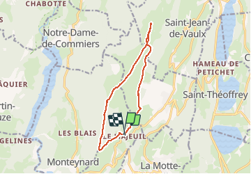
Tocht Stappen van 12,5 km beschikbaar op Auvergne-Rhône-Alpes, Isère, La Motte-Saint-Martin. Deze tocht wordt voorgesteld door GuyVachet.
Beschrijving
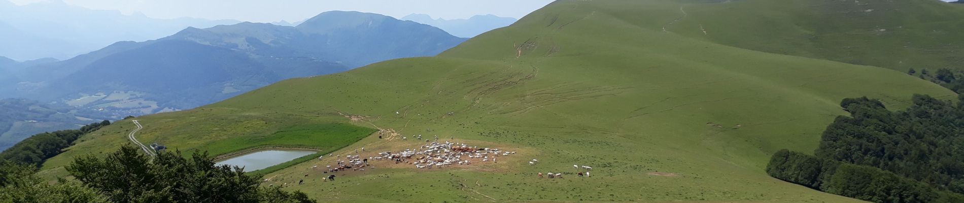
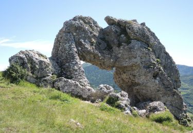
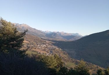
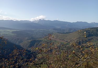
Boucle sur la montagne du Conest depuis Le Majeuil (hameau de Notre Dame de Vaulx) en passant par La Peyrouse (photo 2 depuis Beauregard) et Beauregard. La montée commence rapidement en forêt sur la croupe et il ne reste que 200m à gravir à découvert pour arriver à La Peyrouse qui offre une vue à 360° notamment sur le Vercors et le Mont-Aiguille (photo 1). Redescente au Petit Lac pour remonter à Beauregard (environ 100 m). Le retour se fait par le chalet de l'As par un sentier ombragé très agréable. A la cote 1159, ne pas s'engager sur le retour direct sur Le Majeuil car le sentier disparait rapidement. Il est préférable de revenir sur Notre Dame de Vaulx quitte à revenir au Majeuil (sentier de 2 km).
Plaatsbepaling
Opmerkingen
Wandeltochten in de omgeving
![Stappen Stappen](https://static1.geolcdn.com/sitytour/trail-icons/101.png)
Stappen
![](/images/other/stat-length.png)
![](https://static1.geolcdn.com/siteimages/upload/files/16400158638029165_repeat_loop_refresh_sync_direction_icon.png)
![Tocht Mountainbike Pierre-Châtel - Tour des lacs Pierre-Chatel - Photo](https://media.geolcdn.com/t/375/260/ext.jpg?maxdim=2&url=https%3A%2F%2Fstatic1.geolcdn.com%2Fsiteimages%2Fupload%2Ffiles%2F1524743154velo.jpg)
![Mountainbike Mountainbike](https://static1.geolcdn.com/sitytour/trail-icons/202.png)
Mountainbike
![](/images/other/stat-length.png)
![](https://static1.geolcdn.com/siteimages/upload/files/16400158638029165_repeat_loop_refresh_sync_direction_icon.png)
![Tocht Stappen La Motte-Saint-Martin - connex en boucle - Photo](https://media.geolcdn.com/t/375/260/a85b9cb7-206d-4f86-ae8b-a6cb3e334179.jpg&format=jpg&maxdim=2)
![Stappen Stappen](https://static1.geolcdn.com/sitytour/trail-icons/101.png)
Stappen
![](/images/other/stat-length.png)
![](https://static1.geolcdn.com/siteimages/upload/files/16400158638029165_repeat_loop_refresh_sync_direction_icon.png)
![Tocht Stappen La Motte-d'Aveillans - petite balade - Photo](https://media.geolcdn.com/t/375/260/c8ab192f-feb7-4747-af86-e7381ac953ed.jpg&format=jpg&maxdim=2)
![Stappen Stappen](https://static1.geolcdn.com/sitytour/trail-icons/101.png)
Stappen
![](/images/other/stat-length.png)
![](https://static1.geolcdn.com/siteimages/upload/files/16400158638029165_repeat_loop_refresh_sync_direction_icon.png)
![Tocht Stappen La Motte-Saint-Martin - connex - Photo](https://media.geolcdn.com/t/375/260/874cc892-61da-4872-9785-f7893aa41f95.jpg&format=jpg&maxdim=2)
![Stappen Stappen](https://static1.geolcdn.com/sitytour/trail-icons/101.png)
Stappen
![](/images/other/stat-length.png)
![](https://static1.geolcdn.com/siteimages/upload/files/16400158638029165_repeat_loop_refresh_sync_direction_icon.png)
![Tocht Stappen La Motte-Saint-Martin - Sinepi - Photo](https://media.geolcdn.com/t/375/260/ext.jpg?maxdim=2&url=https%3A%2F%2Fstatic1.geolcdn.com%2Fsiteimages%2Fupload%2Ffiles%2F1553511878bg_sport_marche.png)
![Stappen Stappen](https://static1.geolcdn.com/sitytour/trail-icons/101.png)
Stappen
![](/images/other/stat-length.png)
![](https://static1.geolcdn.com/siteimages/upload/files/16400158638029165_repeat_loop_refresh_sync_direction_icon.png)
![Tocht Mountainbike La Motte-d'Aveillans - Le Sénépy depuis Les Signaraux - Photo](https://media.geolcdn.com/t/375/260/48b7fa7e-1a2a-4b01-b381-61d2b963f1f0.jpg&format=jpg&maxdim=2)
![Mountainbike Mountainbike](https://static1.geolcdn.com/sitytour/trail-icons/202.png)
Mountainbike
![](/images/other/stat-length.png)
![](https://static1.geolcdn.com/siteimages/upload/files/16400158638029165_repeat_loop_refresh_sync_direction_icon.png)
![Tocht Stappen La Motte-d'Aveillans - Col du Sénépy et Pierre Plantée depuis les Signaraux - Photo](https://media.geolcdn.com/t/375/260/cfea585a-9c0d-41ae-ace9-cab390a4faa0.jpg&format=jpg&maxdim=2)
![Stappen Stappen](https://static1.geolcdn.com/sitytour/trail-icons/101.png)
Stappen
![](/images/other/stat-length.png)
![](https://static1.geolcdn.com/siteimages/upload/files/16400158638029165_repeat_loop_refresh_sync_direction_icon.png)
![Tocht Stappen La Motte-d'Aveillans - Les Signaraux - La Pierre Plantée - Le Serre de L'Horizon - Le Col du Sénépy - Photo](https://media.geolcdn.com/t/375/260/092bd114-492b-4995-ab4f-f2010f6926fc.jpg&format=jpg&maxdim=2)
![Stappen Stappen](https://static1.geolcdn.com/sitytour/trail-icons/101.png)
Stappen
![](/images/other/stat-length.png)
![](https://static1.geolcdn.com/siteimages/upload/files/16400158638029165_repeat_loop_refresh_sync_direction_icon.png)